Following last summer's record minimum ice cover in the Arctic, current observations from ESA's Envisat satellite suggest that the extent of polar sea-ice may again shrink to a level very close to that of last year.
See the map at right animated by following this link to the European Space Agency.
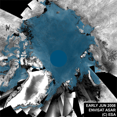
Envisat observations from mid-August depict that a new record of low sea-ice coverage could be reached in a matter of weeks. The animation above is a series of mosaics of the Arctic Ocean created from images acquired between early June and mid-August 2008 from the Advanced Synthetic Aperture Radar (ASAR) instrument aboard Envisat. The dark grey colour represents ice-free areas while blue represents areas covered with sea ice.
Current ice coverage in the Arctic has already reached the second absolute minimum since observations from space began 30 years ago. Because the extent of ice cover is usually at its lowest about mid-September, this year's minimum could still fall to set another record low.
Each year, the Arctic Ocean experiences the formation and then melting of vast amounts of ice that floats on the sea surface. An area of ice the size of Europe melts away every summer reaching a minimum in September. Since satellites began surveying the Arctic in 1978, there has been a regular decrease in the area covered by ice in summer — with ice cover shrinking to its lowest level on record and opening up the most direct route through the Northwest Passage in September 2007.
The direct route through the Northwest Passage - highlighted in the image above by an orange line - is currently almost free of ice, while the indirect route, called the Amundsen Northwest Passage, has been passable for almost a month. This is the second year in a row that the most direct route through the Northwest Passage has opened up.
Read the rest of the story from the source, The European Space Agency via Environmental News Network (ENN)
.
0 comments:
Post a Comment